
Picture your ideal neighborhood: wide, tree-lined sidewalks buzzing with pedestrians, pocket parks where kids play and neighbors chat, and a mix of cafes, shops, and homes all within a short walk. This vision of urban livability doesn’t happen by accident—it starts with urban planning rendering that brings these concepts to life before a single brick is laid. Urban design rendering has become the secret weapon of city planners worldwide, transforming abstract ideas into tangible visions that prioritize human wellbeing over concrete and cars.
Gone are the days of relying solely on technical blueprints that only engineers could decipher. Today’s urban design renders create immersive, photorealistic previews of future cities—powerful tools that help communities visualize and shape places where people want to live.
The Visualization Power of Urban Design Renderings
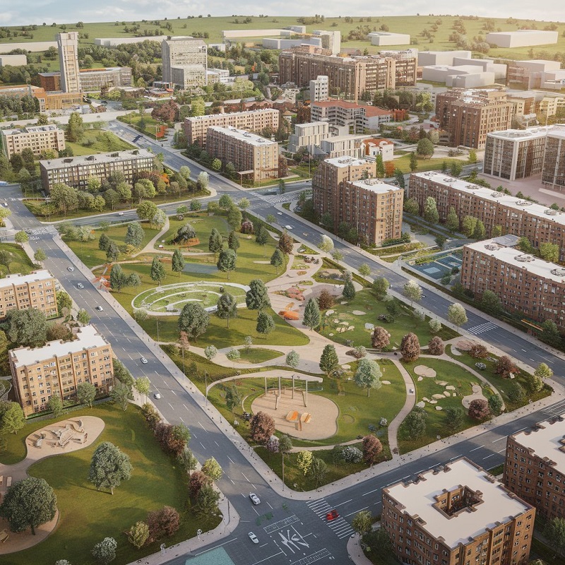
So, what exactly are these magical tools? Urban design rendering represents the evolution from flat, two-dimensional plans to dynamic, three-dimensional experiences. Planners can now create living models of proposed urban spaces using advanced technologies like GIS mapping, BIM integration, and VR walkthroughs.
These aren’t just pretty pictures. A well-executed city planning rendering accounts for everything from sunlight patterns across public plazas to pedestrian sightlines along shopping corridors. It can simulate how crowds flow through a new transit hub or how shadows from high-rises might affect neighborhood parks. This level of detail turns abstract planning concepts into something residents and decision-makers can genuinely understand and evaluate.
Core Principles of Livable Urban Design
The best urban design plan rendering focuses on several key human-centric principles. Walkability stands at the top—creating neighborhoods where daily needs are within a comfortable walking distance, with sidewalks wide enough for friends to stroll side by side under the shade of mature trees.
Access to green space follows close behind, whether it’s grand central parks or small “pocket parks” tucked between buildings. Mixed-use development comes next, blending homes, shops, and offices to create around-the-clock vitality rather than deserted business districts after 5 PM.
Efficient public transit reduces reliance on cars while connecting communities. And thoughtfully designed public spaces—from splash pads to chess tables—become the living rooms of the city, fostering chance encounters and community bonds.
How Renderings Improve Urban Livability
Here’s where urban design project renderings prove their real value:
- Testing concepts safely – Want to know if a proposed plaza will feel welcoming or windswept? A rendering can simulate sun, shade, and sightlines at different times of day before construction begins.
- Democratizing planning – When residents can virtually “walk through” a proposed development rather than squint at technical drawings, public feedback becomes more meaningful and inclusive.
- Securing funding – Compelling visualizations help decision-makers understand the value of investments in green infrastructure or pedestrian zones.
- Identifying problems early – That beautiful boulevard rendering might reveal sight distance issues for drivers or dead zones that could attract loitering.
- Bridging communication gaps—Renderings create a common language for discussing urban futures between planners, engineers, politicians, and residents.
Transformative Examples from Global Cities
Barcelona’s “superblock” program offers a perfect case study. Early urban design renders showed how reclaiming street space from cars could create pedestrian plazas and playgrounds where asphalt once dominated. These visuals helped convince skeptical residents and businesses, leading to a transformation that reduced noise pollution by 40% in some areas while increasing social interaction.
Singapore’s vertical greenery initiatives similarly relied on compelling renderings to demonstrate how skyscrapers could become “vertical forests,” improving air quality and resident wellbeing. The visual proof helped justify the additional construction costs, creating the city’s now-iconic green skyline.
Emerging Technologies in Urban Visualization
The future of urban design rendering looks even more revolutionary. AI-powered tools can now generate multiple design alternatives based on key parameters—testing hundreds of variations of a streetscape to optimize sunlight, wind patterns, and pedestrian flow.
Augmented reality apps allow residents to point their phones at vacant lots and see proposed developments in situ. Digital twins create living models of entire cities that update in real time, letting planners simulate the impact of new policies or infrastructure projects.
Perhaps most crucially, climate modeling now integrates with visualization tools, showing how designs will perform under extreme heat, heavy rainfall, or other climate challenges—helping create cities resilient enough for future generations.
Key Considerations for Effective Visualizations
Of course, even the most beautiful rendering has limitations. There’s an art to balancing aspirational visions with practical realities—showing what’s possible without creating false expectations. The best visualizations use accurate lighting conditions rather than a perpetual golden hour, include realistic human activity rather than empty perfection, and represent diverse community members rather than homogeneous crowds.
Residents’ input ensures renderings reflect actual community needs rather than just architectural fantasies. Maintaining a clear connection to budgets and construction timelines keeps projects grounded in reality while still inspiring better urban futures.
Conclusion
At its heart, urban design rendering represents more than technical innovation—a profound shift in city planning. By making urban futures visible, tangible, and debatable, these tools empower communities to shape places that prioritize people over pavement, connection over congestion, and wellbeing over mere functionality.
The cities our grandchildren inherit will be shaped by the visualizations we create today. With powerful urban design rendering tools and inclusive processes, we can ensure that future cities are efficient and livable.